Sancutary River Packraft – August 2016
Twenty four hours, two bears, one lost hiker, two packrafts and one wrong turn
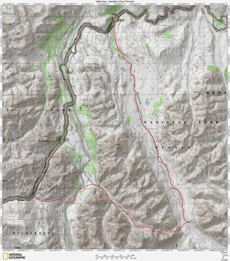
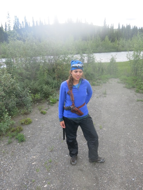
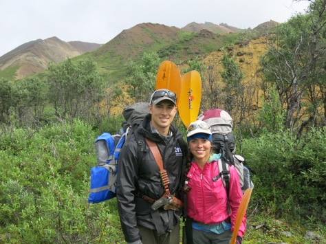
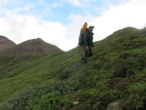
We catch the Denali Park camper bus out to Sable Pass, with all gear ready to go into our backpacks. People with varying amounts of gear get dropped off here and there along the meandering park road. About an hour and a half in (with multiple stops for animal sightings) the bus leaves us right at the top of the pass. There are no formal trails in Denali’s backcountry, but this is a popular destination and a hiker’s trail leads down from the steep slope where the road is. Making sure we have bear spray and the .357 ready, we make our way down the trail to our first river crossing. Looking up and downstream, we quickly realize avoiding this is futile. May as well get our boots wet in the first 10 minutes.
The first part of the trip takes us downhill from the Sable Pass through thick swampy muscag and bushes. All the while we maintain conversation, or at most make noises, wary of what bears we might accidentally catch unawares. We pass through multiple streams and ponds, trying to get into the main valley of the Teklanika River below. The wide braided and rocky stream bed is our destination. After a while the well defined hikers trail fades and we begin the first bushwacking of the trip through dense bush and forest.
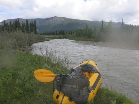
Arriving at the Teklanika, the clouds roll in and it begins to rain. We have been playing catch up with the weather all day and it finally hits us. We look at the map, about 5 miles to the next valley that we need to hike up into, down to the southwest of us. It makes sense to turn this stretch into our first bout of rafting! Inflating the rafts and securing our packs, we get into the river. It has been raining so the water is high and fast. We were here the year before battling shallow river beds and getting stuck. Making our way downstream it is a constant labyrinth of widening and narrowing river paths.
We pull out our rafts at the mouth of the next valley we must enter in order to get to the pass and the Sanctuary river beyond which will take us back to the park road. By now it is approaching evening. The sky never will get entirely dark today, but the light changes and the mountains change to an orange hue. We cross the river early on, in a spot where we can make it across without getting in the white water. The river is high here, and we sidestep our way across together, hands on shoulders.
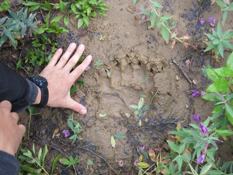
The first part of the walk we follow the river bed on the south side. At first I welcome the rocks after sinking and making slow progress through the muskag earlier. The rocks eventually give way to bigger boulders, and the hiking here is also slow, weighed down by the 50lb of gear and packrafts we both carry. About an hour into this hike, we spot tracks in the silt of the river bed. What appear to be wolf tracks head upstream, immediately followed by bear paw prints. Water is seeping into the cracks in the silt that were punctured by the bears claws. The grooves are deep and dark in the silt. After this I am looking up and down the valley sides more and more.
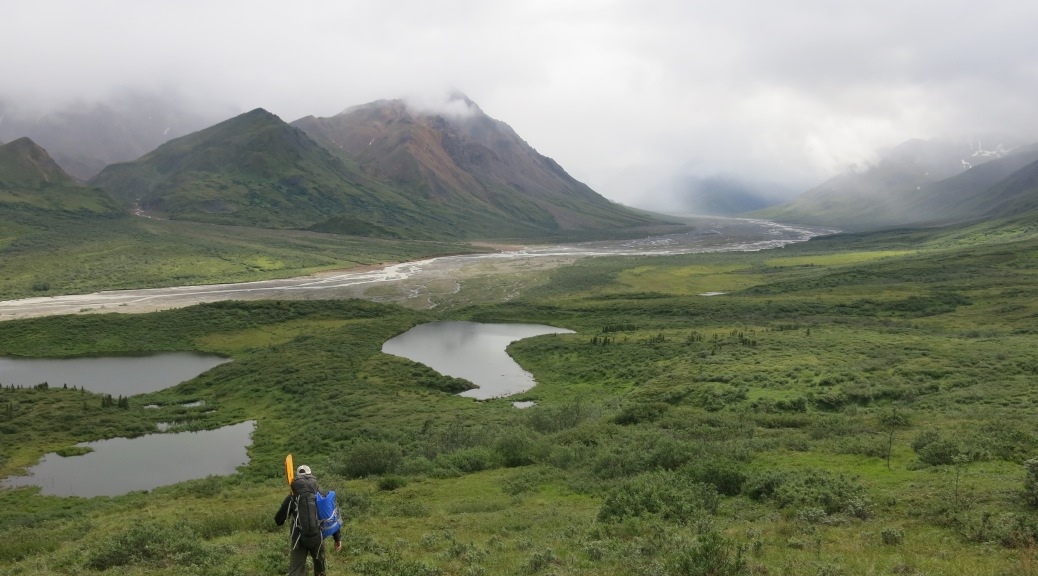
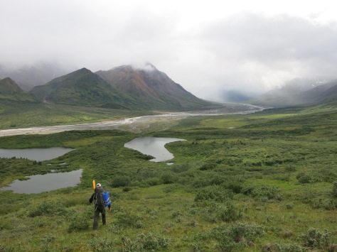
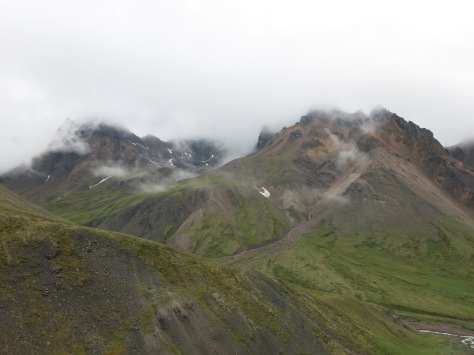
We head up the valley along grassy bluffs that follow the river below. After walking up the river channel on hard rocks, the grass feels great underfoot. As we follow the bluffs upstream, they begin to rise high above the river below. We now have a view of the entire valley. The bluffs are green and covered in mountain wild flowers. Bellow the river is grey and throthing. On either side of the valley, tall red-stained granite cliffs rise. The sky is grey-black filled with passing rain clouds. The dark clouds and red cliffs cast a dramatic contrast to the green pasture like slopes we tread on. Across the valley I see what looks like white dried trees. On closer inspection, a herd of caribou is grazing high up on the valley sides.
We reach a junction where the river we have been following is being joined by a different river from another valley. This river comes from the mountains and is much clearer than the churning grey river we follow. They combine, in a swirling pattern downstream, until they blend, and are indistinguishable.
The grassy bluffs we follow now begin to steepen. We traverse the grassy slope across a fairly steep section. A fall here would take you one hundred feet into the valley which is has now become more of a gorge. After the traverse, the terrain flattens somewhat to rolling meadow above the gorge. We continue to follow this up to the mountain pass above. Grass and mountain flowers are slowly replaced by dirt, then rocks, until we are trudging up a pile of scree.
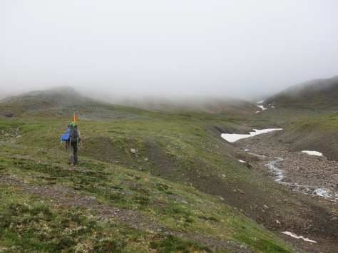
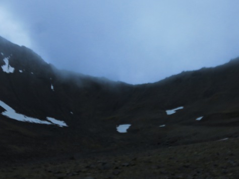
It is approaching midnight as we arrive at the pass. Up in the mountain col, the sky is dark and misty and it is hard to make out the distances that we see in the silhouette of mountain ahead of us. This is the first time I turn on my GPS to make sure we are heading for the correct pass that we had been planning to take. Sure enough, the pass is actually just 100 feet ahead, completely obscured by the darkness and mist!
The pass is easily climbed. From the top, an entirely new valley awaits us. We make our way down a very steep scree slope, where each step into the scree forces us to glissade down by two feet or so. This quickly transports us to the valley below. When we finally get to the bottom, it is about 2 in the morning. We decide to set up a tent for a quick 2 hour power nap. After we will descend this valley to reach the headwaters of the Sanctuary and rafting portion of our trip.
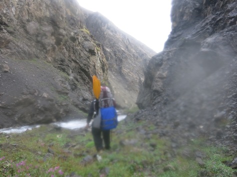
After a very chilly sleep (we had not brought sleeping bags) we pack up the tent and again make our way down. We begin to walk down the river that carves a path between the valley sides. This valley is made out of dark slate and scree slopes. The slopes quickly begin to steepen around us, and the path alongside the river is narrowing. What was once a path is turning into boulders with rushing water that we must gingerly step down to make progress. We arrive at a section of waterfall where it is necessary to remove packs to place them around the corner so that we can climb down. My pack slips in the process and the river takes it with it, until it is caught in a pool at the base of the next waterfall.
At this time we realize we cannot continue without a rope. The best bet is trying to climb up the steep valley side, to the bluffs we know must be above. The slope is very steep, and it is necessary to do some scrambling at the top of the grass and scree to make it to the top of the cliff. I take my bag off for this so that I can push it up over the rocks first. After a bit of precarious rock scrambling, I make it over the cliffs and arrive at the gentle 25 degree slopes of the bluffs! We sit in the grass drying out under the sun. In contrast to the dark cliff lined valley we have just climbed out of, it feels like being in a garden! The sun comes out at this time to greet us and dry our clothes and packs that were drenched by the waterfall descent.
After recuperating, we begin the easy walk down. I can see the headwaters of the Sanctuary ahead. A much wider, deeper and faster river than the Teklanika. I am grateful we decided to climb out of the gorge when we did. On our way down the waterfalls get taller and taller – likely unpassable without rope or injury.
We get down to the Sanctuary river and begin to unload the rafts. I am welcoming the change from walking to rafting as it has been already about ten hours on feet! Looking at the map we look for the features we need to recognize from the river which tells us we are entering the wolf enclosure and must put out. This leaves us with another 6 miles of walking to do after the river. Not particularly excited about that concept but at least there is a 15 miles interlude of river.
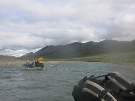
We begin downstream. It is not raining today, and being on the water feels amazing. Near the headwaters, the river is slow and easy with many sand bars and it is possible to float happily without too much concentration. The many peaks and valleys with their own tributaries coming to meet our river welcome us down stream. The peaks around us are green and punctuated by waterfalls pouring from river gorges that drain the glaciers and snow above. This portion of river is truly idyllic.
After floating for an hour we see something that gives us halt. A man is walking alone along the river, looking disheveled with all belongings in a plastic shopping bag he clutches at his waist. He waves and calls to us, but the river takes us fast away. Before having started our trip, we knew that someone was missing. This person is about 20 miles south of where the search party is, and fits the description extremely well. We decide the best course of action is to get back to the park road as quickly as possible so that we can report him.
Rafting now becomes our mission. As the river goes downstream and is joined by tributaries, the pace quickens. We also leave the sparsely vegetated open river valley that the headwaters were in, to an area filled with spruce pines. The occasional branch or tree in the river poses an important obstacle to avoid. A fallen tree in a river is called a strainer, and getting caught in one in a raft can be dangerous as the weight of the water rushing from behind you will pile up. It is very important to be paying attention in order to navigate these.
After about two hours on the river I am getting cold and hungry. The river has slowed and is meandering, with many sand bars that appear to be tempting spots to stop for a lunch break. I see a bar around the corner ahead that appears a good candidate. Turning around, I call out to ask whether this is a good place to stop. Sean shouts something in a harsh voice that I don’t at first get. Then I understand he is saying ‘BEAR!’. Looking back at the sandbar that my packraft is now drifting into, I see that the perfect lunchbreak sand bar is already occupied – by two grizzlies devouring a caribou! The bears’ snouts and claws are covered in the blood of the half eaten creature, whose ribcage is fully exposed and stripped of meat.
Sean takes out his bear spray behind me, while I do my best to navigate my boat away from the current pulling me to the animals. One bear looks up when he hears us and begins to walk into the river, which is at most 2 feet deep here. At this point I am probably two car lengths from the animal. Much closer than I would like!
We make it around the corner and the bears seem to lose interest in us as they resume their bloody feast. I continue down river. No longer hungry. No longer feeling the cold. Heart pounding! After this I am excited to make it back to the park road. Regain composure. Report the lost hiker. We make a unanimous decision to take the closed portion of the river pack to the road, saving us probably 2 hours of travelling through the back country.