
DAY 0 – New York City I take a last minute inventory of my gear in my room in Manhattan before I leave to catch my flight for Fairbanks, Alaska. I will be taking my Bianchi Volpe cross bike with both rear and front panniers. I replace the 32CC tires that came with the bike for the larger 38CC variety, hopefully wide enough to give me a stable ride on the 400 mile unpaved Dalton Highway. A cyclists’ travel guide from the Bureau of Land Management informs me that the following conditions will be met on the roads: mud the consistency of wet cement, gravel so deep you need to pedal to go down hills, and grapefruit sized bits of rock. I also pack four extra inner tubes with my patch kit, anticipating at least one if not more flat tires on the way! The weather at Prudhoe Bay (the start of my journey) is hovering around freezing with forecasted snow. The end of my journey (Fairbanks) is much warmer, with temperatures in the 60 – 70 F range. I pack a variety of winter, rain and summer cycling clothes, ready for whatever I will meet. I also have my lightweight REI one person sized tent, air mattress, sleeping bag, other general camping gear. I also throw in my headlamp and batteries… although I will be enjoying twenty-four hours of daylight as I bike through the Arctic into the summer solstice. Force of habit I guess. ‘Boswell’s London Journal’, a chronicle of life in 18th century London also makes it into my gear. I am hoping to have at least some downtime. Altogether (including my bike, bags and bodyweight) I am traveling with 250 lbs! 
DAY 1 – Arrival at Prudhoe Bay (June 7th 2014) As the airplane begins its descent to Prudhoe Bay, I start to get second thoughts on the trip I am about to begin. The plane breaks through a thick fog, and a few snow flurries before reaching the wet and frozen airport tarmac below. All I can see outside is white, frozen ground as far as the eye can see, and broken up ice on the frigid Arctic Ocean. This flight from Fairbanks is making two stops: number one is Prudhoe Bay and the second is Barrow (only accessible by plane). As passengers whose final destination is Prudhoe Bay begin to disembark I suddenly envy the other passengers staying safely on board!

In the small terminal of the Prudhoe Bay Airport, I wait with anticipation for my bike gear. Did I remember everything? Do I have my tent? And my sleeping bag? And food?! Also did the bike that I packed three days ago in my New York apartment in the company of a friend from my graduate school program and under the influence of a few beers, make it in one piece? My fears are put to rest as everything arrives safe and sound!

It takes about an hour to rebuild my bike, pump up my tires, pack my bags, and fill my water bottles. I leave the cardboard box I used to transport my bike in the airport, where the airport worker I give it to tells me that it will be used for hunters to transport antlers in. Glad to know recycling is going on.

I head out into the charming Prudhoe Bay, the northernmost town on the Dalton Highway. The town exists to serve as a base for oil exploitation taking place in the Arctic. The Dalton Highway which reaches this far north, was built in a mere 154 days in 1974 to support the Trans-Alaska Pipeline, which delivers oil from the Arctic down to Valdez. This is the 414-mile route I will be following, alongside the pipeline which crosses through Arctic Tundra, the Brooks Range and the White Mountains as it extends south towards the Pacific.


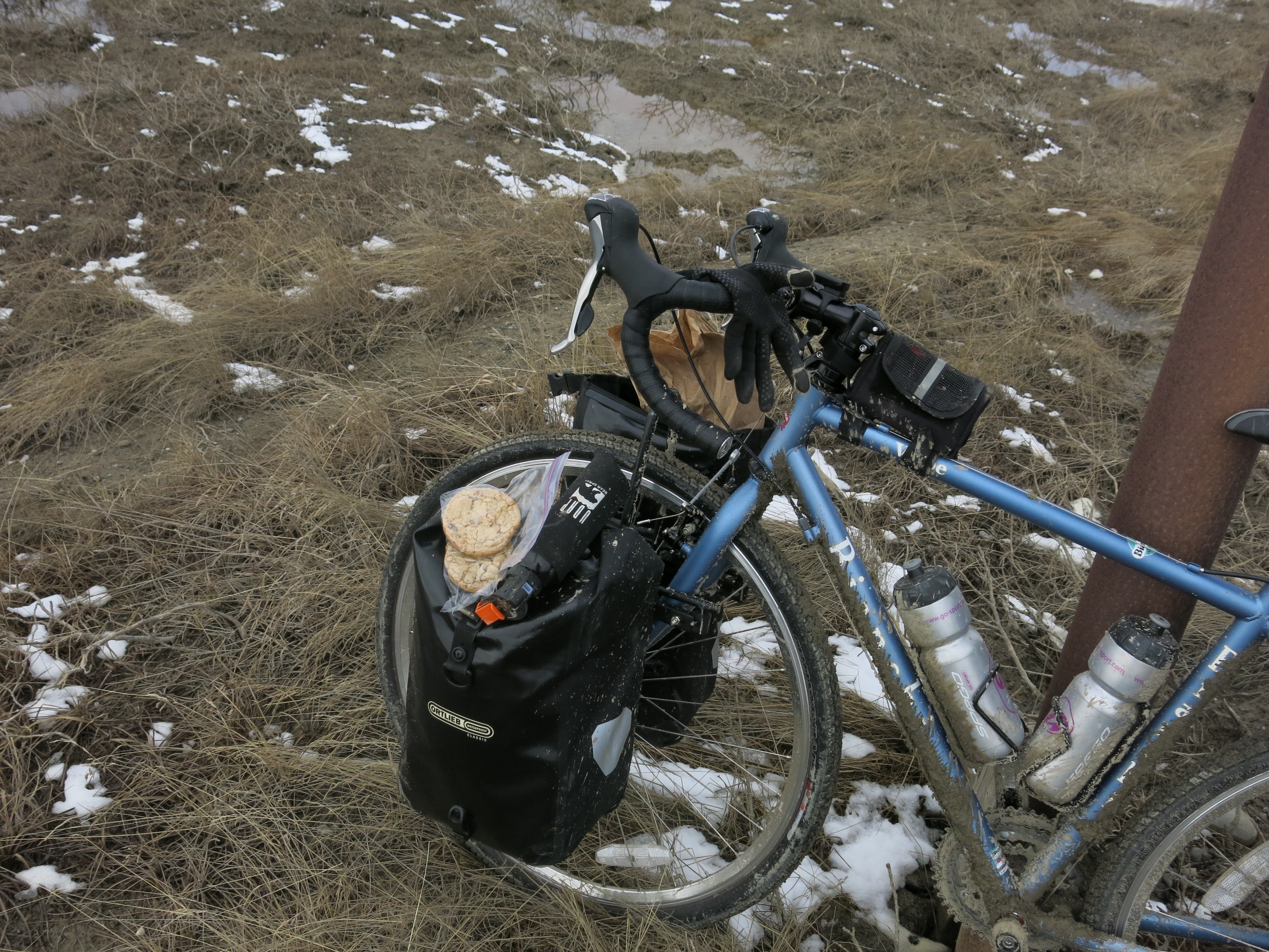
I stop at a the Prudhoe Bay General Store, which sells tools, hardware, a few post cards as well as some snack foods. I am very glad that I carried all my food on the plane and did not rely on this store, as I would otherwise be eating overpriced and probably stale Snickers Bars for the rest of the journey. I purchase some Coleman Fuel for the stove. I do not intend to do much cooking, but there’s nothing like a cup of coffee before starting 80 mile days on a bike in the Arctic. At the general store, a man who has just been driving North informs me that there has been a grizzly bear sighting about 60 miles down the Dalton Highway. Welcome to Alaska I guess. For today I will keep my bear spray strapped to the outside of my Ortlieb biking bags!!


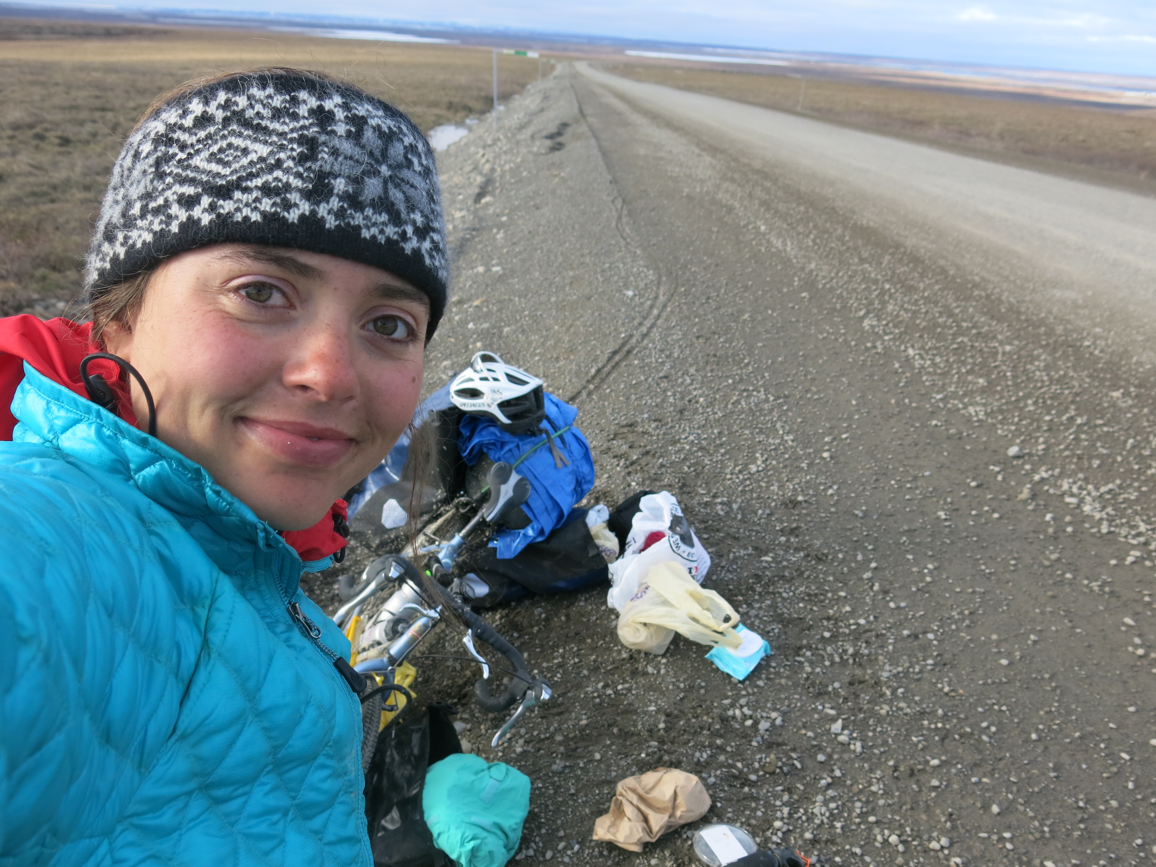
As I roll out of Prudhoe Bay, I see this daunting sign above. Next Services 240 miles. I have a long way to go before I can buy my next cup of coffee, and purchase any emergency food should I need to. Or spend any money whatsoever for that matter!

As I bike south I am surrounded by frozen arctic tundra, with a view of the pipeline in the distance carrying oil south. The roads are flat, but the mud is so deep it takes twice as much effort to travel as it would normally though. I also realize very quickly that there is little point in trying to stop mud from getting just about everywhere: on my clothes, bike pedals, gears, cogs, face, the works. I also discover that it is necessary for me to maintain at least 5 km/ hour pace even in the thickest mud or my fork swings out of control and I would be propelled into the mud. This sounds simple enough, but trying it with a fully loaded (and hastily packed) touring bike and the situation becomes more difficult. I practice ’emergency’ unclipping from my bike pedals to prepare for any such falls.


I run into a policeman (Charles) along the way who stops to see how I am doing. He also lets me know there are few other cyclists one to two days ahead of me en route to South America. And also a pack horse team traveling from Prudhoe Bay down to Mexico! It appears that I am undertaking the shortest trip of all. Anyway its comforting to speak to someone who is familiar with the area, and assures me others are doing this too. Officer Charles gives me lunch and a drink that he carries with him just in case. Its nice I don’t have to dip into my stock of peanut butter just yet.


It’s hard to stop cycling when the sun never goes down, and each bend of road produces new stunning scenery. I see its 10:30 pm and I decide to finally make camp for the night. I have biked about 75 miles today and that is more than enough for me to complete the trip in good time. Just as I am about to set up camp however, I have my first encounter with wildlife! A grizzly bear (small-ish I suppose by average grizzly standards) is just off the side of the road. The bear does not even look up once as it is busy foraging for roots, food, whatever it wants out in that field. I bike past slowly and confidently… At 11 with the sun shining fully I set up camp and make sure to put all my food FAR away in a bear proof sack, don’t want any unwanted attention from this little fellow.


DAY 2 –
I wake up cold, but after a cup of coffee I am good to start the day. Plus I will be getting warm today since the hills start after around 90 miles from Prudhoe Bay. At the bottom of one particular hill, ‘Oil Spill Hill’ which is particularly steep, I notice my second bear of the trip. This one seems HUGE compared to the last, and I also feel disadvantaged going uphill at such a slow rate. 


The beginning of mountains start to appear on the horizon as I make distance today. The foothills of Brooks Range are looming, and are beautiful, but also remind me of the Brooks Range ‘Atigun Pass’ – the highest elevation on this trip, I will have to go through. Sometime in the afternoon, I pass by a group of construction and pipeline workers who are helping out at the site of a crash where an 18-wheeler drove off the road the day before. In most areas, the Dalton Highway is built up about 15 feet off the surrounding area which means driving off it is a very dangerous risk. Each time I pass one of the enormous trucks I try to keep to the side to avoid a similar fate for me and my bike.
Later that afternoon, I have an encounter with a different type of arctic predator – a great white wolf! Unlike the bears I have seen, the wolf stops in its tracks as it is bounding across a field and watches me bike. Although it is far from me, I can tell it is enormous – much bigger than a dog. I wait for it to get to a safe distance away from the road before yanking out my camera for a shot.

Further along the road, construction work is going on. A large truck is spraying the road with water, turning it into a thick, gloopy mud that makes pedaling much harder than it should be. The advantage of the wet surface is that dust clouds are not created with each passing truck, which cover me in dirt and leave me biking momentarily blinded. I am approaching the construction site fast, in fact my speedometer tells me I am going around 30 miles per hour down a hill with no chance of breaking due to the heavy load I am carrying. A construction worker yells at me to stop but I find I actually cannot do it. Further along when the road starts to bend uphill, I finally can control my bike where I meet another worker who pulls up to me in a pick-up. The worker – Michael- informs me that I am not actually allowed to bike through the work site by state law, and I agree (without too much resistance) to put my bike in the car to cross over to safety. Michael tells me about life in Alaska – how you stay awake all summer for the 3-4 months of perpetual day light and then join the animals in hibernation for the winter. We also talk about the Dalton Highway. He describes it to me perfectly as “Miles and miles of miles and miles” – a phrase that sums up how it feels being on this thin strip of mankind passing through wilderness.


DAY 3 –
I end up camping just at the foot of the Brooks Range. After biking towards storm clouds and lightning flashes the previous afternoon, I decided to get a good rest before continuing on to the Atigun Pass. The Atigun Pass marks the highest elevation reached on the Dalton Highway at 4739 feet (1444 m) and when heading from the North, involves a gradual rise following the Dietrich River and eventually a few serpentine turns. The road reaches a grade of 12% which on a fully loaded touring bike makes for slow progress.
As I bike through toward the pass by the Dietrich River, the sides of the valley begin to move closer together. The weather also begins to change, as orographic precipitation is formed as air masses move up the mountain. I leave the sunny plains of the tundra behind me and head on into a light drizzle and black rain clouds. I also am not alone on this part of the route – as I bike steadily (and oh so slowly) uphill a large grizzly can be seen traversing over the valley. Bear number three of the trip – I am averaging one per day. As with the other two, I feel honored to see such a beautiful animal in the wild (although true, I may have felt differently had their been closer encounters).


It is a relatively decent and gradual climb up to the start of the Atigun Pass. Just at the base, as I stop to take a photograph, a group of about 5 motorcycles pass me. I have seen many touring groups of motorcycles, and frankly think the journey looks scarier as they are still on the same unpaved and unruly road but going much faster! I wave off to the bikes, switch to my lowest gear and start the slow progress up the pass. A sign at the base warns me of avalanches and ‘not to stop’ – not sure if moving at 3 miles per hour constitutes ‘moving’ but I try to not loiter, particularly at the location of a previous avalanche!


Finally I reach the top of the pass, after several photo and rest breaks. As soon as I arrive I am promptly greeted by a rain storm. The gravel road on the way down looks to me like a river filled with rocks, deep mud sections, and overall not ideal for biking. It is an easy choice to me – I walk my bike down the first especially steep section, a bit of an anticlimax after the grueling uphill, but I would rather live to bike more hills in better conditions! After the steepest part is over, I remount and begin a cautious descent, fully squeezing my breaks. On the way down I notice the smell of popcorn – can I really be that hungry to be making up odors all the way out here? I then realize it is the smell of my brake rubber which is burning with all the pressure I am putting on them! Right about now I am wondering if I should have brought spares…
After the Atigun Pass the scenery changes rapidly. The arctic tundra I had been biking through the previous two days is replaced by larger shrubs, and finally trees! In fact, a plaque marks the location of the northernmost spruce pine at mile post 235 – however when I get there I find that the tree has been cut down – I learn later as an act of vandalism. It seems like a strange, not to mention far, location for vandalism and I wonder at the motivation of such a crime. I do am happy to note that plenty more spruce pine appear to be even further north than this one though.
The rest of the afternoon is rainy, muddy and finally BUGGY! When preparing for the trip I had been warned that the mosquitoes are ferocious in Alaska in the summer, and no amount of bug spray, clothing and netting will keep them at bay. Each time I take a break in the forested area, a cloud of mosquitoes is conjured up out of nowhere, attracted to my body heat. Luckily – and this is my theory – the blanket of mud over my body keeps them relatively uninterested and I emerge from Day 3 unscathed.


Day 4
I spend a night camping beneath the pipeline. There are pullouts for pipeline maintenance all the length of the Dalton Highway, which also serve as great and easy places to pitch a tent. I feel a trip following this highway, which was constructed for the sole purpose of reaching the oil fields in the North, would not be complete without sleeping beneath the pipeline. The pylons holding it up also make a great hideaway for my bear proof bag containing my life blood, a.k.a. peanut butter.
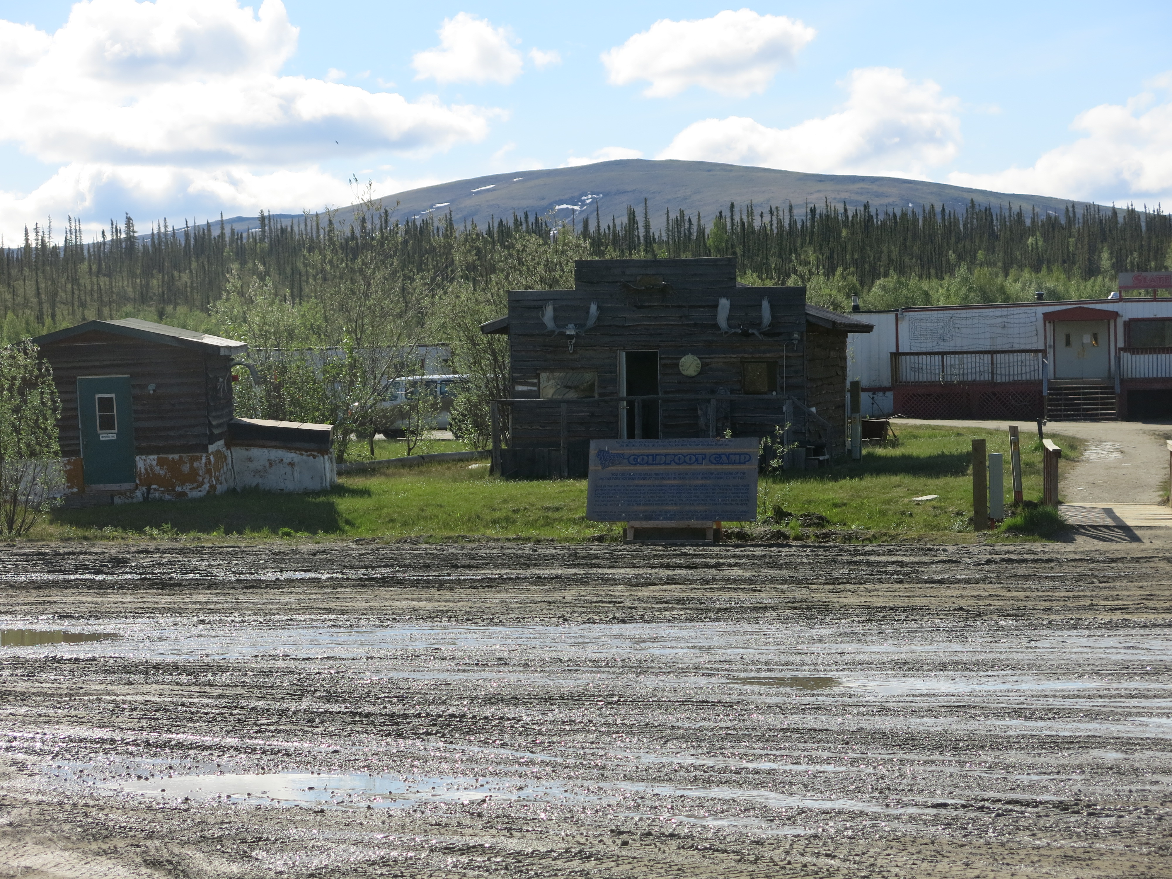
My campsite is only 15 miles away from Coldfoot, and 240 miles away from where I started in Prudhoe Bay. Coldfoot will be the first ‘town’ that I come across, although town might be a slight exaggeration as when I arrive I find there are a few buildings, a gas station for the truckers, a post office which is open 3 days a week and a restaurant. I order my first real food for the trip – since its breakfast I go for a plate of scrambled eggs and rye toast and LOTS of real coffee, which is a nice change from the instant I have been brewing outside my tent. At Coldfoot I also get reprimanded for biking by a trucker who must have passed me earlier. He tells me that what I am doing is very dangerous – and I guess on a road not used to tourists maybe it is. I also meet a group on motorbikes who are just finishing a journey up from Texas. As usual my journey seems to be the shortest!
Having biked through the Brooks Range the day before, I am feeling both cocky and confident that the worst is over. I could not be more wrong, and I quickly discover this as I begin to enter the White Mountains. I spend the rest of the afternoon biking up and down numerous mountain passes.
I eat lunch at the beautiful South Fork Koyukuk River. I can tell that many more moutains lie ahead. Looking through my food I realize that no matter how many hills I climb, I will necessitate another entire jar of peanut butter or 2 bags of walnuts, or 2 huge loaves of bread. In the interest of preserving my already aching knees, I leave a bag with my food on a car parked nearby, and a note explaining I am on a bike and am looking to ditch some extra weight. In retrospect, I realize this could have been an error and hope that no animals destroy the hood of this car eating my surplus goodies! I also regret telling them I am on a bike.. .better keep a low profile now.
After biking along for a few hours, I run into two more cyclists! Since there are so few of us on the road, the sight of others who are also sharing this experience, merits stopping. Again these two – brothers from Florida – are at the beginning of a much longer trip from Alaska to Argentina! We exchange stories about our ride thus far – yes we are all sore, yes the quality of the road is terrible but it is still the experience of a lifetime. After a chatting for a while, a white pick up truck pulls up and the driver informs us that a grizzly bear is slowly heading our way from a few miles north (incidentally . This provides a logical end to the conversation, I wish them luck with their journey and head on.
After a long and challenging afternoon, I arrive at the Arctic Circle for 9 pm. The Arctic Circle features a sign and a primitive campsite which I stay in. It is the first time on the trip I stay in an ‘official’ campsite, and although it is still very wild the difference is I share it with a few other travelers. It is somehow not as serene as the lonely pull out of the pipeline from the previous night, but I get a wonderful nights rest through a heavy rain storm.


DAY 5
A heavy rain is falling on and off when I wake up at the Arctic Circle, making it difficult for me to leave the comfort of my dry, warm tent. During an interlude in the rain I finally decide to start packing up. The pause in rain also summons a cloud of mosquitoes that work on my skin as I work on packing away my things. Today will be a day for all my rain gear.
The roads are immediately unforgiving after leaving my campsite at the Arctic Circle. After a five minute ride I encounter the first of an impossibly steep, straight and painfully long hill called ‘Beaver Slide’. As I begin my slow trajectory up this part of road, drenched in rain and sweat, several jeeps pass me and I receive a number of incredulous looks. Needless to say, I am still having fun!
After around forty minutes spent tackling Beaver Slide, I enjoy a few short downhill sections and then approach an even longer ascent – Finger Mountain. At this point it is raining even harder, and clouds cover the top the hill and my destination. I am biking on a combination of gravel, mud and sections of cement. Suddenly this firm combination makes way to deep, wet mud and my front fork swivels to the right. As I am already biking so slowly I have no control and I fall down on my side. This is my first crash of the trip, but luckily I am slowly and my panniers act as cushions to my fall. Picking my self up, I am forced to walk a section until the grade becomes gentle enough to remount. Finally I arrive at the top, and enjoy a rainy peanut butter sandwich along with views of the top.
The afternoon is filled with rolling hills in countryside that looks almost like an Alaskan version of Tuscany, if one was to pretend that the scattered spruce pines were cypress trees. At some point, the more or less hard packed and even gravel I have been cycling over is replaced by thick mud that gets trapped in my wheels, brakes, chain and pedals. I bike until I am forced to stop to clear up the mess forming on my bike. Progress is slow and it is still raining. It is beautiful however, with dramatic black skies contrasted against green pine trees and reddish-brown dirt.
Steep hills come one after another, and I finally approach the infamous ‘Roller Coaster Hill’ which is less thrilling on a bike than the name would suggest. Today the Dalton Highway has truly defeated me, and I am forced to walk up the final segments of several of these beasts.
An afternoon of pain brings me to the Yukon River, a wide body of water that begins in British Columbia and bisects the State of Alaska to its mouth in the Bering Sea. The sun never goes down, but I arrive at 9 pm when the light is coming at an angle and the river is illuminated by shades of pink, orange and yellow which are reflected in its rippling waters. It is beautiful to behold and a true prize for this long 60 mile day.


Excellent writing about your journey down the Dalton thanks for sharing. If you want I have a Dalton Highway DVD I will send you for free since I don’t believe you managed to shoot any video. You can check me out at my blog and even see a trailer from the video by clicking on the ad on the right column. If you want the DVD just contact me and let me know. Again thanks for the great story.
LikeLike
This is Amazing!!!!
LikeLiked by 1 person